Skip to main content
Top Navigation
About
News
Careers
Contact
TAP
MV E-Services
Top Navigation
About
News
Careers
Contact
TAP
MV E-Services
TAP
MENU
MENU
Main navigation
Individual
Individual
General Information
E-File Information
Where's My Refund?
Individual Income FAQs
Individual Income Tax Forms
Individual Income Tax
Responsible for the administration of Mississippi tax laws including the collection and processing of individual income tax returns and payments.
Business
Business
Sales & Use Tax
Sales & Use Tax
Intro to Sales and Use Taxes
Sales Tax Rates
Sales Tax Exemptions
Use Tax
Tourism and Economic Development Taxes
Motor Vehicle Rental, Tire Disposal, City Utility Taxes
Registration Information for Sales and Use Tax Applicants
Register for Taxes
Reporting Requirements
Internet Filing for Sales Tax
Guide for Construction Contractors
Corporate Income & Franchise Tax
Corporate Income & Franchise Tax
Combined Income Filing
e-File Program
Tax Clearance Letter
Withholding Tax
Withholding Tax
Withholding Tax Info
Bulk filing of W2s and 1099s
FSET
Interstate Commercial Vehicles
Petroleum Tax
Gaming
Beer
Tobacco
Estate
Finance Company Privilege Tax
Insurance Premium
Oil & Gas Severance
Public Utilities & Railroads
Amusement Ride & Attraction Safety
Salt & Timber Severance
Waste Disposal Fees
Business FAQs
Business Tax
Administers Mississippi business taxes including sales, use, withholding, and other state tax obligations.
Motor Vehicle
Motor Vehicle
Motor Vehicle Titles
Motor Vehicle Titles
Fast Track Titles
Motor Vehicle Registration & Renewal
Motor Vehicle Online Tag Renewal
Motor Vehicle Ad Valorem Tax
Motor Vehicle E-Lien Program
Dealers & Designated Agents
Available License Plates
Available License Plates
Specialty License Plates
NASCAR™ License Plates
Special Tag Fee Distribution
MV County Staff Access
Title Status Lookup
Online Dealer Lookup
Motor Vehicle FAQs
Motor Vehicle Services
Oversees vehicle title issuance, registration, license plates, and motor-vehicle related tax collection in Mississippi.
County Services
County Services
Centrally-Assessed Properties
Homestead Exemption
Local Property Appraisal
Property Tax Data
Property Tax Exemptions
County Staff Access
Property Tax FAQs
County Services (Property Assessment)
Supports Mississippi counties with property tax assessments, collections, and homestead exemptions.
ABC
ABC
ABC Enforcement
Permits (Licenses)
Permits (Licenses)
Direct Wine Shippers
Sales & Distribution
Sales & Distribution
Vendor Information
Wholesale Package Retailers
Past Price Changes & SPAs
Medical Cannabis
Medical Cannabis
Dispensary Application
Dispensary Licensee Information
Medical Cannabis Taxation
Registry
Search for an Active ABC Permit
ABC FAQs
ABC Forms
Alcoholic Beverage Control
Mississippi Alcoholic Beverage Control regulates the legal and responsible sale and distribution of alcoholic beverages in the state.
Forms & Resources
Forms & Resources
Form Search
Make Online Tax Payments
Laws & Regulations
Notices & Technical Bulletins
Statistics
Taxpayer Guidance
Taxpayer Guidance
Appeal Process & Hearings
Audit Procedures
Mississippi Tax Structure
Record Keeping & Document Retention
Suspension & Revocations
Tax Guidance
Incentives & Credits
Incentives & Credits
Tax Incentives
Charitable Credits
Procurement
Bankruptcy
General FAQs
Forms & Resources
Provides access to tax forms, instructions, publications, and helpful resources for Mississippi taxpayers and professionals.
Top Navigation
About
News
Careers
Contact
TAP
MV E-Services
Main navigation
Individual
Show Sub Menu
General Information
E-File Information
Where's My Refund?
Individual Income FAQs
Individual Income Tax Forms
Business
Show Sub Menu
Sales & Use Tax
Intro to Sales and Use Taxes
Sales Tax Rates
Sales Tax Exemptions
Use Tax
Tourism and Economic Development Taxes
Motor Vehicle Rental, Tire Disposal, City Utility Taxes
Registration Information for Sales and Use Tax Applicants
Register for Taxes
Reporting Requirements
Internet Filing for Sales Tax
Guide for Construction Contractors
Corporate Income & Franchise Tax
Combined Income Filing
e-File Program
Tax Clearance Letter
Withholding Tax
Withholding Tax Info
Bulk filing of W2s and 1099s
FSET
Interstate Commercial Vehicles
Petroleum Tax
Gaming
Beer
Tobacco
Estate
Finance Company Privilege Tax
Insurance Premium
Oil & Gas Severance
Public Utilities & Railroads
Amusement Ride & Attraction Safety
Salt & Timber Severance
Waste Disposal Fees
Business FAQs
Motor Vehicle
Show Sub Menu
Motor Vehicle Titles
Fast Track Titles
Motor Vehicle Registration & Renewal
Motor Vehicle Online Tag Renewal
Motor Vehicle Ad Valorem Tax
Motor Vehicle E-Lien Program
Dealers & Designated Agents
Available License Plates
Specialty License Plates
NASCAR™ License Plates
Special Tag Fee Distribution
MV County Staff Access
Title Status Lookup
Online Dealer Lookup
Motor Vehicle FAQs
County Services
Show Sub Menu
Centrally-Assessed Properties
Homestead Exemption
Local Property Appraisal
Property Tax Data
Property Tax Exemptions
County Staff Access
Property Tax FAQs
ABC
Show Sub Menu
ABC Enforcement
Permits (Licenses)
Direct Wine Shippers
Sales & Distribution
Vendor Information
Wholesale Package Retailers
Past Price Changes & SPAs
Medical Cannabis
Dispensary Application
Dispensary Licensee Information
Medical Cannabis Taxation
Registry
Search for an Active ABC Permit
ABC FAQs
ABC Forms
Forms & Resources
Show Sub Menu
Form Search
Make Online Tax Payments
Laws & Regulations
Notices & Technical Bulletins
Statistics
Taxpayer Guidance
Appeal Process & Hearings
Audit Procedures
Mississippi Tax Structure
Record Keeping & Document Retention
Suspension & Revocations
Tax Guidance
Incentives & Credits
Tax Incentives
Charitable Credits
Procurement
Bankruptcy
General FAQs
Home
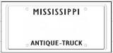
Antique Truck Vanity
Search
Search
License Plate Category
Available License Plates
License Plate Image